Detail
Tangggal iklan:
Kota: Tangerang Selatan
Merk: Hi Target
Kondisi: Baru
Penjual
Nama: Nusatama Store
Terdaftar sejak: 4 Agustus 2016
Status:

No Telpon: 0817-XXXX-XXXX
No Handphone: 0812-XXXX-XXXX
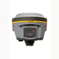
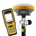
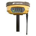
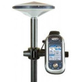
Spesifikasi Produk JUAL GPS Geodetik Hi-Target V30 GNSS RTK
GPS Geodetik Hi-Target V30 GNSS RTK
Spesifikasi Produk GPS Geodetik Hi-Target V30 GNSS RTK
Multi-constellation tracking
• 220 tracking channels.
• Supports GPS, GLONASS, GALILEO, BDS, SBAS.
• NGS approved GNSS antenna.
Intelligent operation
• Equipped with a smart speaker guiding the whole operation.
• Multi one-button functions make fieldwork easier, such as auto base setup by one button, the rover can get fix solution once it is turned on.
Diversify RTK application
Optional transceiver UHF radio
• The transceiver UHF radio enables the working mode to be switchable between base and rover.
• 2-watt HI-TARGET internal UHF radio and 2-watt Pacific Crest TrimTalk© internal UHF radio are optional. Pacific Crest
TrimTalk© internal UHF radio is compatible with other radios.
Removable internal UHF radio enables users to fix or exchange simply.
Seamless operation in CORS system
• Built-in GPRS/GSM/3G module ensures that the V30 works perfectly with network RTK positioning.
Long-life battery
• Powered by 5000mAh Li-ion battery.
• Static working time 13 – 15 hours.
• RTK Rover (UHF/GPRS/GSM) working time 10 – 12 hours.
• RTK Base working time 8 – 10 hours.
Rugged and unique design
• IP67 dust/water protection.
• Withstands 3-meter natural fall onto concrete.
• Rapid tracking and perfect avoidance or reduction of obstruction and multipath effect to ensure superior positioning capability.
MEASUREMENTS
• 220 Channels
• Advanced Pacific Crest Maxwell 6 Custom Survey GNSS Technology
• High precision multiple correlator for GNSS pseudo range measurements
• Unfiltered, unsmoothed pseudo range measurements data for low noise, low multipath error, low time domain correlation and high dynamic response
• Very low noise GNSS carrier phase measurements with 99.9%
RealtimeKinematic(RTK) surveying
Horizontal: 8mm+1ppm RMS
Vertical: 15mm+1ppm RMS
Initialization time: typically < 8 seconds
Initialization reliability: typically > 99.9%
Code Differential GNSS positioning
Horizontal: 25cm+1ppm RMS
Vertical: 50cm+1ppm RMS
SBAS[iv]: 0.50m Horizontal, 0.85m Vertical
HARDWARE
Physical
Dimensions (W x H): 19.50cm x 10.40cm(7.68 in x 4.09 in)
Weight: 1.3kg (2.86lb) with internal battery, internal radio, standard UHF antenna
Operating temperature: -45℃to +65℃ (-49℉ to +149℉)
Storage temperature: -55℃ to +85℃ (-67℉ to +185℉)
Humidity: 100%, considering
Water/dustproof: IP67 dustproof, protected from temporary immersion to depth of 1m (3.28ft).
Shock and Vibration: Designed to survive a 3m(9.84ft) natural fall onto concrete.
Electrical
Power 6V to 28V DC external power input
Power consumption 2.5W
Automatic Switching between internal power and external power
Rechargeable, removable 7.4V, 5000mAh Lithium-Ion battery in internal battery compartment
Internal battery life
Static 13 – 15 hours
RTK Rover (UHF/GPRS/3G) 10 – 12 hours
RTK Base 8 – 10 hours
I/O interface
1 x Bluetooth
1 x standard USB2.0 port
2 x RS232 serial port
2 x DC power input (8-pin & 5-pin)
COMMUNICATION AND DATA STORAGE
GPRS/GSM or 3G
Fully integrated, fully sealed internal GPRS/GSM or 3G
Network RTK (via CORS) range20-50km
HI-TARGET internal UHF radio (standard)
Frequency: 460 MHz with 116 channels
Transmitting Power: 0.1W, 1W, 2W adjustable
Transmitting Speed: Up to 19.2Kbps
Working Range: 3~5Km typical, 8~10km optimal
Pacific Crest XDL micro Internal UHF Radio
Frequency: 403~473 MHz
Transmitting Power: 0.5W, 1.0W, 2.0W adjustable
Transmitting Speed: Up to 19.2Kbps
Support most of radio communication protocol
Working Range: 3~5km typical, 8~10km optimal
HI-TARGET External UHF radio (standard)
Frequency: 460 MHz with 116 channels
Transmitting Power: 5W, 10W, 20W, 30W adjustable
Transmitting Speed: Up to 19.2Kbps
Working Range: 8~10Km typical, 15~20km optimal
Pacific Crest ADL Vantage Pro External UHF radio
Frequency: 390~430 MHz or 430~470 MHz
Transmitting Power: 4W to 35W adjustable
Transmitting Speed: Up to 19.2Kbps
Support most of radio communication protocol
Working Range: 8~10Km typical, 15~20km optimal
Support other external communication device
For example, external GSM modem.
Data storage
64MB internal memory
Data formats
(1Hz positioning output, up to 50 Hz – depends on installed option)
CMR: sCMRx, CMR, CMR+input and output
RTCM: RTCM 2.1, 2.2, 2.3, 3.0, 3.1 input and output
Navigation outputs ASCII: NMEA-0183 GSV, AVR, RMC, HDT, VGK, VHD, ROT, GGK, GGA, GSA, ZDA, VTG, GST, PJT, PJK, BPQ, GLL, GRS, GBS Navigation outputs Binary: GSOF
1 Pulse Per Second Output
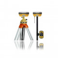
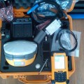
1 BASE :
1 Unit GPS mainframe
2 Unit BL-4400 lithium battery
2 Unit TB-1 connector
1 Unit CL-4400 battery charger
1 Unit TB-10 connecting rob (pole kuning)
1 Unit Meteran 3m
1 Unit UHF-46 receiver antenna
1 Unit Tripod
1 Unit Tribrach
1 ROVER :
1 Unit GPS mainframe
2 Unit BL-4400 lithium battery
1 Unit GC-3 data cable GPS
1 Unit CLS2-1 pole carbon
1 Unit USB-A data cable controller
1 Unit CL-2000A controller charger
1 Unit CL-4400 battery charger
2 Unit BL-2000A controller battery
1 Unit TB-1 connector/adapter
1 Unit HDT-5 controller bracket
1 Unit UHF-46 receiver antenna
1 Controller
Nusatama Store
Jl.H.Sapri No.32 Pondok Aren
Tangerang Selatan – 15224
Sales : Ambar
Hp : 0812-8985-4242 / 0817-675-5161
Pin BB : 277F253D / 2BC8CF8F
juga menyediakan berbagai produk
– Alat Geologi – Alat Laboratorium
– Alat Tuluis Survey – Alat Ukur, Arus Air/angin
– Automatic Level/Water Pas – Camera
– Kompas/Klinometer/Altimeter
– Digital Theodolite – Drone
– GPS – Hammer Test
– Perahu Karet – plotter
– Radio Komunikasi – Telepon Satelit
– Teropong – Test & Measurement
– Total Station
– Weather Station
GPS Geodetic Hi-Target V30 GNSS RTK
Rp 180.000.000
Rp 1.100.000
Telepon Satelit Thuraya Xt 081289854242
Rp 15.500.000
 English